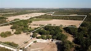
You probably haven’t thought much about the boundaries of your land since you bought it, unless you are in a dispute over a fence or an overgrown garden. There are no lines on the ground that show where your property ends and begins your neighbor’s.
The importance of parcel boundaries is not limited to neighborly disputes. They are also important in thousands of business, legal and government decisions made every day. Here are five things you might not know about parcel boundaries.
What is the difference between parcel boundary and parcel data?
A parcel is land that has a parcel boundary. The parcel boundary is a perimeter that determines how the parcel will look.
A parcel can be defined either as a point or a shape. A boundary can be translated onto a map as a polygon. No matter how many angles or curves there are, the shape allows for a complete definition. A parcel can be defined by a point located on a map using latitude andlongitude. Sometimes only one point is defined per parcel. This point can have different levels of precision. It could be the rooftop or centroid (the point in the middle of a parcel), or even a zip code. It is important to keep in mind that no matter how precise the latitude/longitude point, it does not tell the entire boundary story.
Why is it important to have parcel boundaries?
There are many reasons why parcel boundaries matter. Here are just a few of them:
- Boundaries give perspective, such as distances from landmarks or points-of-interest.
- Visualizing the geographic data helps the user understand.
- They allow for more complex analysis to create greater insight.
- Changes in boundaries can help tell the time.
What are the boundaries used for?
Different industries require parcel boundaries for different reasons.
In land records management parcel maps are used to show the exact location of each parcel boundary. These maps, also known as assessor maps, allow anyone to see the boundaries of their property. These maps are used by county assessors to determine the size of land, which impacts value and tax amounts. They use shape to track the ownership of each piece.
Utility companies like gas and electricity may need to identify properties which could be affected by a power outage, or find the best place to lay new cables, wires, or pipe.
Lenders might want to know which properties in their portfolio have been affected by a disaster. Title companies may also need to calculate the distance from a potential danger, such as a gas station, industrial area, or a landfill.
Evolution from Paper to Digital
Parcels used to be drawn on large-format paper maps. Assessors would write on each parcel a unique identifier (sometimes called an Assessor Parcel Number, or APN), which was used to track the parcels for tax purposes. Most counties now have a Geospatial Information System (GIS) department that uses mapping software instead of paper to create and maintain parcel borders. Digital maps not only make it easier to manage changes but also make them available online.
Coverage, Completeness, & Currency
First American Data & Analytics holds nearly 2.5 million Assessor map in more than 1,100 counties. These maps cover 70% the U.S. populace, but we have 148 million parcel boundaries in almost every county. As with all First American Data & Analytics data from public records, we link these parcel boundaries to taxable areas defined by the Assessor. Some parcels are not taxed. Federal land, state park, tribal land protected forests, bodies water, streets, railways, and government building are some of the types that don’t get taxed.
Parcel boundaries can be updated through sales. This is important for tracking changes in parcel boundaries. It is important to keep track of these changes by having the most recent parcel boundaries. First American Data & Analytics updates parcel boundaries every quarter and is working to implement solutions that will allow this to happen more often. The fact that the county department responsible for recording documents does not maintain the boundaries is one of the challenges in managing a database. It is therefore possible that changes in parcels and owners due to sales are not in sync the actual parcel boundaries found on the county GIS website. First American Data & Analytics corrects the issue by using Public Record Data. This ensures that the correct owner is associated with a shape and points of a parcel.
The First American Difference
First American Data & Analytics simplifies your job by focusing on accuracy and completeness when collecting and curating parcel information. Since decades, we have collected Assessor maps and Public Record Data and have focused on parcel boundaries and specifically linked them to the right properties because we know their importance to our customers. First American Data & Analytics, with its parcel boundaries and public records data linked together, offers a one stop shop for all the best tabular and spatial property data.
Original Blog: https://dna.firstam.com/insights-blog/5-things-to-understand-about-parcel-boundaries
